Saucier's History of Avoyelles Parish
In 1943, Corinne Saucier, M. A., published a book: History of Avoyelles Parish. In the Chapter on THE DIFFERENT GROUPS OF SETTLERS, and under (Early English speaking settlers): quote “It is impossible to find out just when and where the English-speaking pioneers settled in Avoyelles Parish, but if the account given by a United States agent in 1808 is correct, there were settlers along the Red River at the time of the Declaration of Independence in 1776. A Mr. Holmes was living near the west boundary line, while a Mr. Baker lived near the line on the east at the time this trip was made up the Red River. Both were planters, showing that from the very beginning the settlers realized the value of the rich soil along the streams in Avoyelles Parish.”
As there are no records that exists concerning the originality of the name “Holmesville”, it is reasonable to assume that the place was named after the “Mr. Holmes” mentioned above as, indeed, "Holmesville" is located along the western boundary of Avoyelles Parish.
The name Holmesville began appearing in print around 1830. However, prior to being named Holmesville, the general area was referred to as "Bayou Boeuf Township". For instance, the 1820 U.S. Census of Avoyelles Parish listed the following names as being located at "Bayou Boeuf": Henry Slaughter, J. Fogleman, W. Shaw, Martha Vernon, Matthew Vernon, Elisa Sap, Hartgraves, Elijah Johnson, Ann Ray, Joseph Black, Reuben Ray, Madam Green, George Fogleman, Samuel Dalton, Jacob Keller, N. Day, Edward Willis, William Hargrove, Rueben Parks, S. John Heape, Susan Ham, R. Futch, John Stafford, Stephen Bowie. This census can be compared with that of 1840: Mrs. Frith, James McNeal, Joseph P. O'Neil, P. A. Glaze, Gideon Glaze, R. B. Marshall, John Fogleman, Mrs. Marshall, Fabius Ricord, D. McDonald, John Vinters, William Marshall, J. Glaze, Mrs. Shaw, S. Reed, Edward Watson, William Hargrove, W. L. Stewart. In reviewing these names, it appears that some of the people that lived in the Bayou Bouef Township when the census was taken in 1820 are the same that were in the Holmesville area when a later census was taken in 1840.
Saucier's References Relating to Holmesville
Corinne L. Saucier, History of Avoyelles Parish, Louisiana (Gretna: Louisiana: Pelican Publishing Company, 1998), 119, 121, 283, 403, 404, 411, 412, 415, 416.
- The second post office to open on that date (March 23, 1837) was Holmesville, which was moved to Eola near-by in 1881, when the railroad went through the latter. The early postmasters who served at Holmesville were: Patrick H. Glaze, March 23, 1837; Fabien Ricord, July 20, 1837; Shaw N. Randon, January 27, 1841; Charles Kibbe, July 27, 1842; John W. McDonald, 1854; M. Ferrin, 1866; Sam Haas, 1866; H.O. Tubre, 1867.” p. 119.
- In 1881, (Nov. 14, 1881) the post office of Eola was opened for the first time, or transferred from nearby Holmesville. The postmasters were D.B. Hudson, 1881; William C. Scott, 1884; Mrs. Laura Hudson, 1885; D. B. Hudson, 1888. p. 121.
- Railroads nearly always make a radical change in a community. When the Southern Pacific went through this section (Eola) of Avoyelles Parish in 1881,41 an old town, Holmesville, dating from the earliest years of the century, was left a mile from the railroad; soon all its inhabitants moved closer to the railroad, and thus began Eola. p. 283.
- October 3, 1843: sum of $600 for new bridge across Bayou Boeuf, and for repairing the old one over the Watermelon Bayou. Jacob Keller, R.D. Windes and William Hargrove appointed commissioners to let contract for same, to be paid for in two years. P. 403.
- 1847: F. Ricord’s store in Holmesville in 1847. p. 404.
- 1870: Toll bridge to be erected at Holmesville. p. 411.
- Bridge Expenses, June 1870-1871: Holmesville bridge $1,000.00. p. 412.
- 1873: Watermelon Bayou at Holmesville. p. 415.
- In 1881 Morgan Railroad crossed Bayou Boeuf near Holmesville.
In The Beginning
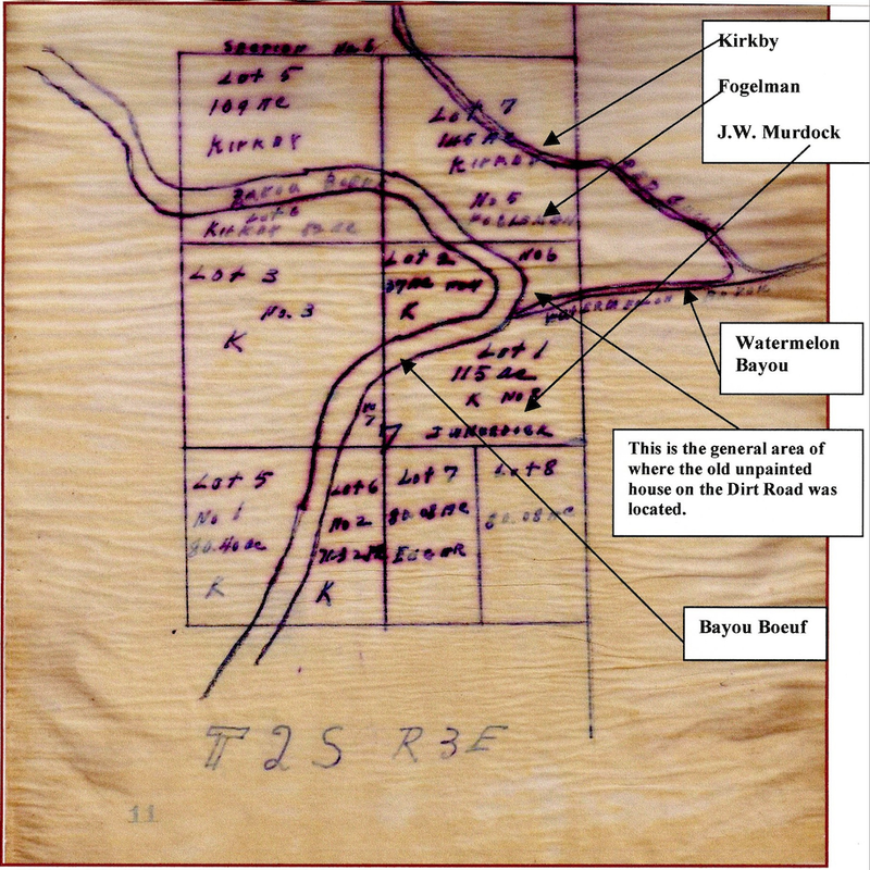
Copy of an 1834 map of sections 6 & 7, Township 2 South, Range 3 East traced by the Amerada Petroleum Corporation, p. 11. Copied from the Abstracts from the Avoyelles Abstract and Land Company, Marksville, Louisiana.
When oil was discovered in the Eola area of Avoyelles Parish in 1939, the large oil companies, such as Amerada Petroleum Corporation, had to be absolutely certain that the royalties from the mineral rights of properties were correctly apportioned. To accomplish this, abstracts of the land and property records had to be researched. In addition to verifying the owners and heirs of the land, there was, surprisingly, (to me at least), a rare gift: the abstracts reflected the history of the ownership of a parcel of land bordering Bayou Boeuf and Watermelon Bayou, particularly of the 20 acres of land where my family lived was before fairly complete -- from the time the United States Government issued Henry Slaughter a Patent to purchase the land in 1818 to the present day. Until 1920, this land along Bayou Boeuf and Watermelon Bayou comprised three separate sections: 1.27 acres; 2.98 acres (the location of our old unpainted house), and another 14.98 acres that is located "between the woods and the North side of Watermelon Bayou". (In January 1899 Ms. Leila Keller purchased the 1.27 and 2.98 acres of land for 300 dollars cash and in September 1920 she acquired the bordering 14.98 acres for "ten hundred fifty and 00/00 dollars".)
Since our old unpainted home was located specifically on 2 of the 2.98 acres of land listed above, this paper focuses on the history of this particular acreage because, as mentioned earlier, this is where I was born and the place where my family lived from 1931 until 1950. The history of these particular 2 acres of land is indeed interesting.
On November 21, 1818, Henry Slaughter purchased from the United States Government one hundred and sixty acres of land that bordered Bayou Boeuf. (The Southeastern quarter of Section 6, Township Two South, Range three East). He claimed this land as a Preemption Right and on which he paid to the United States Government the sum of eighty dollars on the first installment. Mr. Slaughter sold this land to Mr. John Kirby on October 19, 1821 for the sum of five hundred and fifty dollars... being well understood between the contracting parties that the said John Kirby takes upon himself to pay the remaining installments owing to the United States for the said quarter section. (Recorded in Conveyance Book D, Folio 244, Under Entry No. 1455). Witnesses: James Ray, James Thomas. Signed: Henry Slaughter, John Kirby; George King, Parish Judge, St. Landry Parish, Opelousas, Louisiana.
Upon the death of John Kirby in 1833, George King, Parish Judge of St. Landry Parish and Ex-officio Judge of Probate notified Louis Bordelon, Parish Judge and Judge of the County of Probate in and for the Parish of Avoyelles, on December 2, 1833 to make a true and faithful inventory and appraisement of all the property situated in this Parish belonging to the estate of the late John Kirby deceased. (Succession Sale. January 11, 1834. Recorded Conveyance Book A-88, Folio 231, Under Entry No. 57606 one of two pages).
To accomplish this task, Louis Bordelon, proceeded with Messrs. Patrick H. Glaze and Issac Griffith to inventory all the property in the Parish of Avoyelles belonging to the estate of the late John Kirby. Upon completion, the Kirby estate was advertised in the Marksville Villager that the property would be sold at public auction. (Witnesses: Corneluis Avachier, William D. Mayo, Isaac Griffith, Patrick H. Glaze. Louis Bordelon, Parish Judge & Judge of Court Probate). The land is now described as follows:
On January 11, 1834, Judge Louis Bordelon presided over the succession sale at a public auction of the following parcel of land included in the Kirby Estate. The land is now described as follows:
Three years later, on February 13, 1837, Patrick H. Glaze sold the same section of land noted above for the sum of four thousand dollars to Dejean, Taylor and Co., which was composed of Evariste Dejean, John J. Taylor and Adolphe Garrigues, all of the Parish of St. Landry. (Recorded in Conveyance Book N, Page 47, under entry No. 4147. Witnesses: F. Corson, Vanhille Fils; Signed: Patrick H. Glaze, John J. Taylor, A. Garrigues, Eve. Dejean. Labiche, Notary Public). The parcel of land is now described as follows:
(Pls. note the changes: to include all the buildings and improvements erected thereon. This means that the buildings and improvements raised the price of the land considerably. One can also make the argument that the buildings and improvements included the old unpainted house that my family and I lived in on the Dirt Road - a review of the photo of the old house that was taken in 1949 depict a house that appears to be well over one hundred years old). From these records, it is reasonable to conclude that our old home on the Dirt Road was built by Patrick H. Glaze between 1834 and 1837.
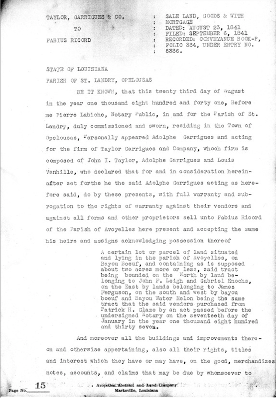
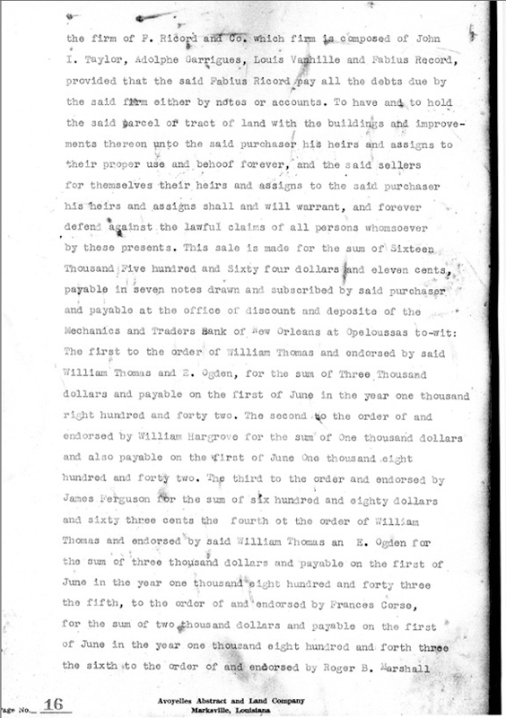
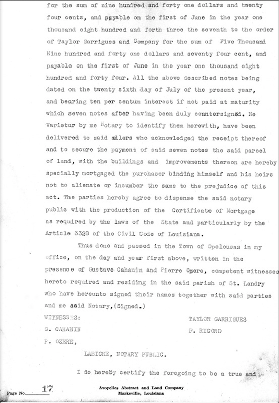
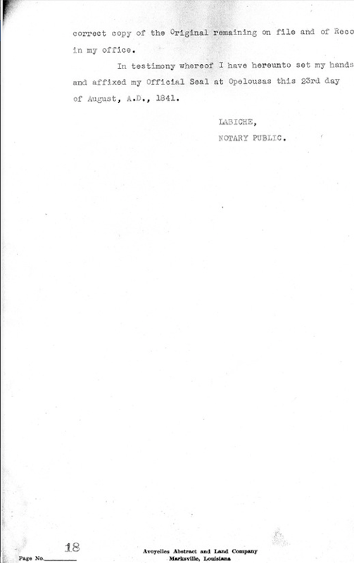
On August 23, 1841, Taylor, Garrigues & Co., sold the land and buildings to Fabius Ricord for sixteen thousand five hundred sixty four dollars and eleven cents. (Recorded in Conveyance Book P, Folio 334, under entry no. 5336. Witnesses: Gustve Cahanin, Pierre Ozere. Signed: Taylor, Garrigues, Fabius Ricord. Labiche, Notary Public, St. Landry Parish). The land is now described as follows:
On April 13, 1849, Fabius Ricord sold the tract of land described above to Isaac E. Morse for the sum of three thousand dollars cash. (Recorded in Conveyance Book U, Folio 292, Under Entry No. 7085. Witnesses: Shaw Newman Randon, Gilbert T. Nelson. Signed: Fabius Ricord, Isaac E. Morse. Ferdinand B. Coco, Recorder, and Ex-Ofiicio Notary Public, Marksville, Parish of Avoyelles, State of Louisiana). On the same day, April 13, 1849, Isaac Morse sold the same parcel of land to Shaw Newman Randon for two thousand four hundred dollars. (Recorded in Conveyance Book U, Folio 293, Entry No. 7086. Witnesses: Fabius Ricord, Gilbert T. Nelson. Signed: Andrew C. Armstrong agent, Shaw Newman Randon. F.B. Coco, Recorder).
Note: The above purchase of two acres of land by Fabius Ricord for $16,564. It must have been close to a record price. Research indicates that land speculation was rampant during this period of time in Avoyelles Parish. With Holmesville being an outpost village, perhaps Mr. Ricord speculated that this was the place of the future, being on the banks of Bayou Boeuf with it's excellent farming land and open space. It should also be noted that after a few years on Bayou Boeuf some of the settlers moved on to Texas when the Republic of Texas received statehood in 1845. "Gone to Texas" was a familiar quote in this period of time.
However, another landowner, Charles Kibbe who acquired land that bordered the immediate east of Fabius Ricord, provided part of the answer for the declining land values. He was forced to have his lawyer appear in court on January 30, 1845. His lawyers, Overton & Dupre submitted the following petition to the Honorable Henry Boyce, Judge of the 6th District Court:
"That by a series of disasters and losses which no providence energy or foresight on the part of your petitioner could avoid growing out of the unprecedented decline in the value of all descriptions of property as well as the staple products of the country, the loss of debts due to him untoward circumstances, your petitioner finds himself embarrassed and unable to meet his engagements all of which will more fully appear to your Honor by reference to the annexed schedule sworn to by your Petitioner as the law directs, containing a summary statement of his affairs, the losses experience the names of his creditors, their residence, the amount of their claims and a list of all his property moveable and immovable, subject by law to the surrender to his creditors with the approximate value thereof. The premises considered your petitioner prays your Honor that his creditors may be convened by due notice, according to law to meet as such, time and place as your Honor may order, and direct so as to enable your petitioner to lay before his said creditors a statement of his affairs and surrender them his estate and that in the meantime all kind of proceedings against his person and property stayed and he further prays to be allowed to make a cession of all of property to his creditors and that the same may be accepted for the benefit of his said creditors and that he may be finally discharged from all responsibility for the same and he also prays for such other and further order, decrease and general relief as the premises and the justice of his case may require."
On January 18, 1853, Shaw N. Randon sold to David C. Keller, the same parcel of land for three thousand four hundred and fifty seven dollars and ninety four cents. (Sale of land with mortgage. Recorded in Alienation Book "X", Folio 412, Entry No. 8044. Witnesses: H.L. Nelson, W.H. Keller. Signed: Shaw N. Randon, David C. Keller. R.L. Tallaferro, Notary Public, Avoyelles Parish). The land is now described as follows:
On January l6, 1855, David C. Keller appeared before Aristide Barbin, Recorder and Ex-officio Notary Public in and for the Parish of Avoyelles and sold the following property to James N. O'Neal for six hundred dollars cash. (Sale of Land. Recorded in Alienation Book "X", Folio 356 under ently No. 8709. Witnesses: Alexander Morrison, Arthur C. Cailleteau. Signed: David C. Keller, James N. O'Neal. Aristide Barbin, Recorder). The land is now described as follows:
On February 21, 1855, James N. O'Neal sold the following property to Mrs. David C. Keller for nine hundred dollars. (Sale of Land. Recorded in Conveyance Book Z, Page 410, under entry No. 8754. Witnesses: E. Z. Griffin, G.T. Nelson. Signed: James N. O'Neal, Amanda J. Keller, David C. Keller. Aristide Barbin, Recorder). The parcel of land is now described as follows:
On April 22, 1868 Amanda O'Neal filed a petition against her husband, David C. Keller, asking to dissolve all their community property which exists between them. (Petition. Recorded in Book "N", Folio 247, under entry No. 5161. Attorneys Irion & Overton).
David C. Keller to Amanda J. O'Neal - March 20, 1872 - Acknowledgment of transfer of land. (Recorded in Conveyance Book LL, Page 732, Under entry No. 2608. Witnesses: John E. Norwood, Jolm E. Vernon. Signed: D. C. Keller, Amanda J. Keller. C. Gray, Justice of the Peace, Fifth Ward, Parish of Avoyelles).
In order to repay a portion of the monies owed to his said wife, Amanda J. O'Neal - which she brought into their marriage - David C. Keller declared that he has transferred and delivered and does hereby transfer and deliver to his Wife, Amanda J. O'Neal in part payment ($500.00) of her said claim, the following described property:
On August 28, 1879, Mrs. David C. Keller, wife of David C. Keller, Sr., sold for five hundred dollars, to Jacob G. Keller, James Keller and David C. Keller, Jr., equal portions of the following land listed below. (Sale of Property. Recorded in Conveyance Book RR, page 639, Under Entry No. 5215. Witnesses: C.A. Gooden, Robert B. Arkenhead. Signed: Amanda J. Keller, D.C. Keller, Sr., David Keller, Jr. Jacob G. Keller, J. James Keller).
On February 11, 1899, Jacob G. Keller sold to Leila Keller for three hundred dollars, the property noted above. (Recorded in Conveyance Book QQQ, Folio 275, Under Entry No. 7082. Witnesses: T.J. Caldwell, W.A. Wilkinson. Signed: Jacob G. Keller, Leila Keller. Robert R. Irion, Notary Public, Eola, Louisiana).
On September 20, 1920, Mrs. Leila Keller purchased the bordering 14 acres on the East of her current property for one thousand fifty dollars.” This purchase, plus her original 5 acres of land gave her a total of 20 acres of land. When Mrs. Leila Keller died in the mid 1940's, the 20 acres of land were acquired by her nephew, Mr. Jack Melder.
This is the same twenty acres of land that my dad farmed from 1931 until the mid-1940's. Today, the twenty acres of land is farmed by L.F. Marchive, Jr. The wooden bridge that crossed Watermelon Bayou is gone. It was replaced by dirt and gravel; a cement culvert is at the bottom to allow the Watennelon Bayou to flow into Bayou Boeuf - a beautiful Louisiana Bayou that is now overgrown with weeds and fallen trees in this area. It's difiicult to believe that such an interesting history of events took place in this general location. Fortunately, the Watermelon Bayou is still called the Watermelon Bayou and that it has not changed names like many of the other places in this area. Looking at the map and trying to locate this exact area is sometimes difficult. This is because the old "Dirt Road" is named the "Oil Field Road". Surely this is not appropriate for a place with such an interesting history. A name such as "Marchive Lane", "Holmesville Village Road" or "Old Holmesville Road" would be justly appropriate.
A list of some of the names referenced as being/living/associated with the Holmesville and Bayou Boeuf area that were taken from the Avoyelles Abstract and Land Company: (Note: These names are limited only to research involving the sale and purchase land involving and surrounding Sections 6 & 7, Township 2 South, Range 3 East).
Henry Slaughter, John Kirby, James Murdock, Patrick H. Glaze, Silas F. Thomas, Isaac Griffith, Fabius Ricord, Dr. John Fenwick Leigh, Gabriel Enochs, James Ferguson, Roger B. Marshall, Thomas D. Marshall, W.C. Marshall, Andrew C. Armstrong, Shaw Newman Randon, Michael Fogleman, John Fogleman, Charles Kibbe, David C. Keller, Robert Singleton, John R. Singleton, Michael L. McJilton, Philip Bridendall, Bamabas S. Gay, M. Vernon, Robert D. Windes, James N. O'Neal, Amanda G. O'Neal (Amanda J. Keller), Alexander Morrisson, Jacob G. Keller, James J. Keller, David C. Keller, Jr., Robert B. Arkenhead, Walter Arkenhead, Dr. C. D. Owens, Leila Keller and Dr. William H. Winn. (Bold = Postmasters at Holmesville).
Since our old unpainted home was located specifically on 2 of the 2.98 acres of land listed above, this paper focuses on the history of this particular acreage because, as mentioned earlier, this is where I was born and the place where my family lived from 1931 until 1950. The history of these particular 2 acres of land is indeed interesting.
On November 21, 1818, Henry Slaughter purchased from the United States Government one hundred and sixty acres of land that bordered Bayou Boeuf. (The Southeastern quarter of Section 6, Township Two South, Range three East). He claimed this land as a Preemption Right and on which he paid to the United States Government the sum of eighty dollars on the first installment. Mr. Slaughter sold this land to Mr. John Kirby on October 19, 1821 for the sum of five hundred and fifty dollars... being well understood between the contracting parties that the said John Kirby takes upon himself to pay the remaining installments owing to the United States for the said quarter section. (Recorded in Conveyance Book D, Folio 244, Under Entry No. 1455). Witnesses: James Ray, James Thomas. Signed: Henry Slaughter, John Kirby; George King, Parish Judge, St. Landry Parish, Opelousas, Louisiana.
Upon the death of John Kirby in 1833, George King, Parish Judge of St. Landry Parish and Ex-officio Judge of Probate notified Louis Bordelon, Parish Judge and Judge of the County of Probate in and for the Parish of Avoyelles, on December 2, 1833 to make a true and faithful inventory and appraisement of all the property situated in this Parish belonging to the estate of the late John Kirby deceased. (Succession Sale. January 11, 1834. Recorded Conveyance Book A-88, Folio 231, Under Entry No. 57606 one of two pages).
To accomplish this task, Louis Bordelon, proceeded with Messrs. Patrick H. Glaze and Issac Griffith to inventory all the property in the Parish of Avoyelles belonging to the estate of the late John Kirby. Upon completion, the Kirby estate was advertised in the Marksville Villager that the property would be sold at public auction. (Witnesses: Corneluis Avachier, William D. Mayo, Isaac Griffith, Patrick H. Glaze. Louis Bordelon, Parish Judge & Judge of Court Probate). The land is now described as follows:
- A tract of land situated on both sides of Bayou Boeuf, containing about six hundred and three American Acres, bounded above by, or tract now in dispute between the heirs of Kirby and John Fogleman and below by Thomas Insale, estimated at ten dollars per acre, making the sum of six thousand one hundred and thirty dollars.
On January 11, 1834, Judge Louis Bordelon presided over the succession sale at a public auction of the following parcel of land included in the Kirby Estate. The land is now described as follows:
- Lot Number six as marked upon the aforesaid plat lying on the East side of Bayou Boeuf and adjoining the Watermelon Bayou below and Lot No. five above containing from ten to fifteen acres more or less, adjudged to Patrick H. Glaze for five hundred and ten dollars, James W. Murdock being his security.
Three years later, on February 13, 1837, Patrick H. Glaze sold the same section of land noted above for the sum of four thousand dollars to Dejean, Taylor and Co., which was composed of Evariste Dejean, John J. Taylor and Adolphe Garrigues, all of the Parish of St. Landry. (Recorded in Conveyance Book N, Page 47, under entry No. 4147. Witnesses: F. Corson, Vanhille Fils; Signed: Patrick H. Glaze, John J. Taylor, A. Garrigues, Eve. Dejean. Labiche, Notary Public). The parcel of land is now described as follows:
- A certain lot or parcel of land situated and lying in the Parish of Avoyelles on Bayou Boeuf; it is well understood, that the land hereby purchased in the whole front of the original tract, as purchased by the said vendor, and running back so far as to include all the buildings and improvements erected thereon, and thence to the nearest point on the Water Melon Bayou to Bayou Boeuf, being part of tract purchased by the said seller at the sale of Kirby Estate.
(Pls. note the changes: to include all the buildings and improvements erected thereon. This means that the buildings and improvements raised the price of the land considerably. One can also make the argument that the buildings and improvements included the old unpainted house that my family and I lived in on the Dirt Road - a review of the photo of the old house that was taken in 1949 depict a house that appears to be well over one hundred years old). From these records, it is reasonable to conclude that our old home on the Dirt Road was built by Patrick H. Glaze between 1834 and 1837.
On August 23, 1841, Taylor, Garrigues & Co., sold the land and buildings to Fabius Ricord for sixteen thousand five hundred sixty four dollars and eleven cents. (Recorded in Conveyance Book P, Folio 334, under entry no. 5336. Witnesses: Gustve Cahanin, Pierre Ozere. Signed: Taylor, Garrigues, Fabius Ricord. Labiche, Notary Public, St. Landry Parish). The land is now described as follows:
- A certain lot or parcel of land situated and lying in the parish of Avoyelles, on Bayou Boeuf, and containing as is supposed about two acres more of less, said tract being bounded on the North by land belonging to John F. Leigh and Gabriel Enochs, on the East by lands belonging to James Ferguson on the South and West by Bayou Boeuf and Bayou Water Melon being the sametract that the said vendors purchased from Patrick H. Glaze by an act passed before the undersigned Notary, Pierre Labiche, Parish of St. Landry, on the seventeenth day of January in the year one thousand eight hundred and thirty seven.
On April 13, 1849, Fabius Ricord sold the tract of land described above to Isaac E. Morse for the sum of three thousand dollars cash. (Recorded in Conveyance Book U, Folio 292, Under Entry No. 7085. Witnesses: Shaw Newman Randon, Gilbert T. Nelson. Signed: Fabius Ricord, Isaac E. Morse. Ferdinand B. Coco, Recorder, and Ex-Ofiicio Notary Public, Marksville, Parish of Avoyelles, State of Louisiana). On the same day, April 13, 1849, Isaac Morse sold the same parcel of land to Shaw Newman Randon for two thousand four hundred dollars. (Recorded in Conveyance Book U, Folio 293, Entry No. 7086. Witnesses: Fabius Ricord, Gilbert T. Nelson. Signed: Andrew C. Armstrong agent, Shaw Newman Randon. F.B. Coco, Recorder).
Note: The above purchase of two acres of land by Fabius Ricord for $16,564. It must have been close to a record price. Research indicates that land speculation was rampant during this period of time in Avoyelles Parish. With Holmesville being an outpost village, perhaps Mr. Ricord speculated that this was the place of the future, being on the banks of Bayou Boeuf with it's excellent farming land and open space. It should also be noted that after a few years on Bayou Boeuf some of the settlers moved on to Texas when the Republic of Texas received statehood in 1845. "Gone to Texas" was a familiar quote in this period of time.
However, another landowner, Charles Kibbe who acquired land that bordered the immediate east of Fabius Ricord, provided part of the answer for the declining land values. He was forced to have his lawyer appear in court on January 30, 1845. His lawyers, Overton & Dupre submitted the following petition to the Honorable Henry Boyce, Judge of the 6th District Court:
"That by a series of disasters and losses which no providence energy or foresight on the part of your petitioner could avoid growing out of the unprecedented decline in the value of all descriptions of property as well as the staple products of the country, the loss of debts due to him untoward circumstances, your petitioner finds himself embarrassed and unable to meet his engagements all of which will more fully appear to your Honor by reference to the annexed schedule sworn to by your Petitioner as the law directs, containing a summary statement of his affairs, the losses experience the names of his creditors, their residence, the amount of their claims and a list of all his property moveable and immovable, subject by law to the surrender to his creditors with the approximate value thereof. The premises considered your petitioner prays your Honor that his creditors may be convened by due notice, according to law to meet as such, time and place as your Honor may order, and direct so as to enable your petitioner to lay before his said creditors a statement of his affairs and surrender them his estate and that in the meantime all kind of proceedings against his person and property stayed and he further prays to be allowed to make a cession of all of property to his creditors and that the same may be accepted for the benefit of his said creditors and that he may be finally discharged from all responsibility for the same and he also prays for such other and further order, decrease and general relief as the premises and the justice of his case may require."
On January 18, 1853, Shaw N. Randon sold to David C. Keller, the same parcel of land for three thousand four hundred and fifty seven dollars and ninety four cents. (Sale of land with mortgage. Recorded in Alienation Book "X", Folio 412, Entry No. 8044. Witnesses: H.L. Nelson, W.H. Keller. Signed: Shaw N. Randon, David C. Keller. R.L. Tallaferro, Notary Public, Avoyelles Parish). The land is now described as follows:
- A certain lot or parcel of Land, situated, lying, being in the town of Holmesville on Bayou Boeuf, in this Parish and supposed to contain two acres more or less, said lot being bounded on the North by lands of John F. Leigh and Gabriel Enoch on the East by lands of James Fergerson, on the South west by Bayou Boeuf and Water Melon Bayou.
On January l6, 1855, David C. Keller appeared before Aristide Barbin, Recorder and Ex-officio Notary Public in and for the Parish of Avoyelles and sold the following property to James N. O'Neal for six hundred dollars cash. (Sale of Land. Recorded in Alienation Book "X", Folio 356 under ently No. 8709. Witnesses: Alexander Morrison, Arthur C. Cailleteau. Signed: David C. Keller, James N. O'Neal. Aristide Barbin, Recorder). The land is now described as follows:
- A certain lot of ground situated lying and being in the Town of Holmesville in this Parish, containing three acres more or less bounded North by lands of the vendor, South by Watermelon Bayou, West by Bayou Boeuf and East by lands of Alexander Morrison & William H. Winn, also all of the improvements thereon situated or in any wise appertaining, being all of the land purchased by the present vendor from S.N. Randon by act of sale duly recorded in this Office in Book X, page 412.
On February 21, 1855, James N. O'Neal sold the following property to Mrs. David C. Keller for nine hundred dollars. (Sale of Land. Recorded in Conveyance Book Z, Page 410, under entry No. 8754. Witnesses: E. Z. Griffin, G.T. Nelson. Signed: James N. O'Neal, Amanda J. Keller, David C. Keller. Aristide Barbin, Recorder). The parcel of land is now described as follows:
- A certain tract of parcel of land situated lying and being on the left descending bank of Bayou Boeuf containing three acres more or less bounded North by lands of Wm. H. Winn, East by said Bayou, South by Water Melon Bayou and West by lands of W.H. Winn and Alexander Morrison, being the same purchased from the said D.C. Keller by the present vendor about twenty or thirty days ago.
On April 22, 1868 Amanda O'Neal filed a petition against her husband, David C. Keller, asking to dissolve all their community property which exists between them. (Petition. Recorded in Book "N", Folio 247, under entry No. 5161. Attorneys Irion & Overton).
David C. Keller to Amanda J. O'Neal - March 20, 1872 - Acknowledgment of transfer of land. (Recorded in Conveyance Book LL, Page 732, Under entry No. 2608. Witnesses: John E. Norwood, Jolm E. Vernon. Signed: D. C. Keller, Amanda J. Keller. C. Gray, Justice of the Peace, Fifth Ward, Parish of Avoyelles).
In order to repay a portion of the monies owed to his said wife, Amanda J. O'Neal - which she brought into their marriage - David C. Keller declared that he has transferred and delivered and does hereby transfer and deliver to his Wife, Amanda J. O'Neal in part payment ($500.00) of her said claim, the following described property:
- A certain lot situated in Holmesville on Bayou Boeuf and bounded on the North by lands of James Keller, South by Water Melon Bayou, East by lands of Mrs. Susan Pickles and Alexander Morrison, and West by Bayou Boeuf containing three acres, more or less, together with all the buildings and improvements thereon.
On August 28, 1879, Mrs. David C. Keller, wife of David C. Keller, Sr., sold for five hundred dollars, to Jacob G. Keller, James Keller and David C. Keller, Jr., equal portions of the following land listed below. (Sale of Property. Recorded in Conveyance Book RR, page 639, Under Entry No. 5215. Witnesses: C.A. Gooden, Robert B. Arkenhead. Signed: Amanda J. Keller, D.C. Keller, Sr., David Keller, Jr. Jacob G. Keller, J. James Keller).
- A certain lot of ground situated in the town of Holmesville, in this Parish, containing four acres, more or less, bounded on the North by lands of James Keller, South by Water Melon Bayou, East by lands of Winn and Morrison and West by public road, together with all the buildings and improvements thereon or thereto appertaining.
On February 11, 1899, Jacob G. Keller sold to Leila Keller for three hundred dollars, the property noted above. (Recorded in Conveyance Book QQQ, Folio 275, Under Entry No. 7082. Witnesses: T.J. Caldwell, W.A. Wilkinson. Signed: Jacob G. Keller, Leila Keller. Robert R. Irion, Notary Public, Eola, Louisiana).
On September 20, 1920, Mrs. Leila Keller purchased the bordering 14 acres on the East of her current property for one thousand fifty dollars.” This purchase, plus her original 5 acres of land gave her a total of 20 acres of land. When Mrs. Leila Keller died in the mid 1940's, the 20 acres of land were acquired by her nephew, Mr. Jack Melder.
This is the same twenty acres of land that my dad farmed from 1931 until the mid-1940's. Today, the twenty acres of land is farmed by L.F. Marchive, Jr. The wooden bridge that crossed Watermelon Bayou is gone. It was replaced by dirt and gravel; a cement culvert is at the bottom to allow the Watennelon Bayou to flow into Bayou Boeuf - a beautiful Louisiana Bayou that is now overgrown with weeds and fallen trees in this area. It's difiicult to believe that such an interesting history of events took place in this general location. Fortunately, the Watermelon Bayou is still called the Watermelon Bayou and that it has not changed names like many of the other places in this area. Looking at the map and trying to locate this exact area is sometimes difficult. This is because the old "Dirt Road" is named the "Oil Field Road". Surely this is not appropriate for a place with such an interesting history. A name such as "Marchive Lane", "Holmesville Village Road" or "Old Holmesville Road" would be justly appropriate.
A list of some of the names referenced as being/living/associated with the Holmesville and Bayou Boeuf area that were taken from the Avoyelles Abstract and Land Company: (Note: These names are limited only to research involving the sale and purchase land involving and surrounding Sections 6 & 7, Township 2 South, Range 3 East).
Henry Slaughter, John Kirby, James Murdock, Patrick H. Glaze, Silas F. Thomas, Isaac Griffith, Fabius Ricord, Dr. John Fenwick Leigh, Gabriel Enochs, James Ferguson, Roger B. Marshall, Thomas D. Marshall, W.C. Marshall, Andrew C. Armstrong, Shaw Newman Randon, Michael Fogleman, John Fogleman, Charles Kibbe, David C. Keller, Robert Singleton, John R. Singleton, Michael L. McJilton, Philip Bridendall, Bamabas S. Gay, M. Vernon, Robert D. Windes, James N. O'Neal, Amanda G. O'Neal (Amanda J. Keller), Alexander Morrisson, Jacob G. Keller, James J. Keller, David C. Keller, Jr., Robert B. Arkenhead, Walter Arkenhead, Dr. C. D. Owens, Leila Keller and Dr. William H. Winn. (Bold = Postmasters at Holmesville).
The Civil War & Holmesville
Please note that these quotes are taken from This Week in the Civil War from "New Age" books. Copied exactly as written including misspelling of words and phrases.
Cartmell, Donald. This Week in the Civil War - May 08, 1863: New Age Books, July, 2001:
Major General George B. Davis, Leslie J. Perry and Joseph W. Kirkley, The Official Military Atlas of the Civil War, (Washington, D. C.: Government Printing Ofliee, 1891-1895.).
Sutton, John W., Chronology of Louisiana ’s 28”’ Infantry in the War for Southern Independence, Chapter VI..
The Civil War Diary of a Private in Company A, 53“ Regiment of Massachusetts Volunteers 1862-1863. (Originally presented by Frank G. Lesure, grandson of Thomas Gardner Lesure, a soldier in Company A of the 53 Massachusetts Volunteers. Mr. Lesure donated a copy of his transcript to the archives of the museum at the Port Hudson State Commemorative site in Louisiana). Note: copied below, misspelled words included, as originally printed.
This map (below) illustrates the "Line of March" of U.S. Force's from Holmesville to Alexandria, Louisiana - under the command of Maj. General Franklin U.S.A. By J G. Oltmanns, Ass't. US. Coast Survey, April 3, 4, 5, 1864. (Next Page).
Cartmell, Donald. This Week in the Civil War - May 08, 1863: New Age Books, July, 2001:
- Spurred by the advance of Admiral Porter and his four gunboats up the Red River, [Maj or General] Nathaniel Banks rouses his army and advances towards Alexandria: “Brig. Gen. C. Grover will march with his command, as soon after the receipt of this order as practicable, towards Alexandria, via Washington and Holmesville, on the Bayou Boeuf Road.”
Major General George B. Davis, Leslie J. Perry and Joseph W. Kirkley, The Official Military Atlas of the Civil War, (Washington, D. C.: Government Printing Ofliee, 1891-1895.).
- Plate 52, Series 1, VolXXX1V Part 1, pp. 218: Route of Major General Franklin with 19 Corps and detachment of 13 Corps.
- (The map depicts Holmesville as being on the route of Major General Franklin in the Red River Campaign in the spring of 1864. In addition, the map indicates that Chicotville" is 14 miles from Holmesville, Evergreen eight miles, and Cheneyville 15 miles.)
Sutton, John W., Chronology of Louisiana ’s 28”’ Infantry in the War for Southern Independence, Chapter VI..
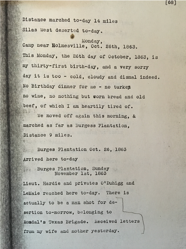
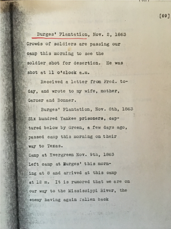
- Date: 10/13/1863. Event: Camped below Holmesville
- Date: 10/26/63. Event: Camped near the Village of Holmesville and remained until November 8.
- Date: 11/08/63. Event: Broke camp at Holmesville.
The Civil War Diary of a Private in Company A, 53“ Regiment of Massachusetts Volunteers 1862-1863. (Originally presented by Frank G. Lesure, grandson of Thomas Gardner Lesure, a soldier in Company A of the 53 Massachusetts Volunteers. Mr. Lesure donated a copy of his transcript to the archives of the museum at the Port Hudson State Commemorative site in Louisiana). Note: copied below, misspelled words included, as originally printed.
- 19 Sunday (April 19, 1863): Rested on a.ct. of Bridge Being built had a heavy thunderstorm
- 20: Marched to Opalousas arrived at 8.o.c. P.M. Men very tired
- 23: Weather hot had new Pottoes, Fred Works died (Fred Works, Company A had been sick some days but helped along by his brother. Buried in the cemetery in Opalousas. Regiment stayed 2 weeks. Had a dress parade on 22 April, p. 89. The army gathered cotton, sugar and molsasses to ship to new Orleans, p.99.)
- Friday 24th: Went on Picket Duty
- May 5th: Left Opalousos marched 20 miles Weather Very hot
- 6: Marched 20 dusty (Passed through Holmesville at 3 p.m., p. 104)
- 7: Marched 25 (Passed through Cheneyville about 2 p.m.., p.104)
- 8: Marched 22 miles to Alexandria on the Red River (Regiment stayed a few days to rest, p. 107.)
- 11: Hird of my Wefes death, died Ap. 8th.
This map (below) illustrates the "Line of March" of U.S. Force's from Holmesville to Alexandria, Louisiana - under the command of Maj. General Franklin U.S.A. By J G. Oltmanns, Ass't. US. Coast Survey, April 3, 4, 5, 1864. (Next Page).
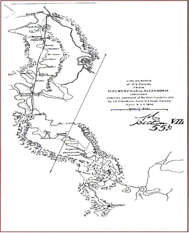
"Line of March of U.S. Forces from Holmesville to Alexandria"
Under the Command of Maj. General Franklin USA
By J.G. Oltmanns, Ass't U.S. Coast Survey
April 3, 4, 5 - 1864
Under the Command of Maj. General Franklin USA
By J.G. Oltmanns, Ass't U.S. Coast Survey
April 3, 4, 5 - 1864
The following two documents are cited from: Arthur W. Hyatt Papers, Mss. 180, Louisiana and Lower Mississippi Valley Collections, LSU Libraries, Baton Rouge, Louisiana:
Burges' Plantation pages from Stuart Salling, Louisiana Civil War Historian
The Burges’ Plantation is located on LA Hwy. 29 just south of Bunkie (built in the early 1800’s)
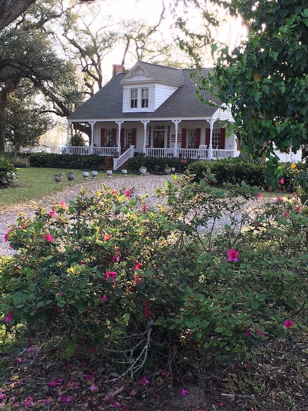
Photos taken in February 2017 by Jerry LaFleur
Diary of Teresa Milburn - "Scribbling"
The following references to Holmesville are from the Diary of Teresa Milburn that she wrote from August 1863 to May 1865, while living at the Milburn Plantation home on Bayou Boeuf in Gold Dust. The title of her Diary is “Scribbling”.
January 5, 1864
Five years ago tonight how well do I remember – I, in company with Brother, attended a “party” given in Holmesville, at Mr. W.H. Bossett’s, who was then a merchant there. ….That was the first and only party I ever attended on Bayou Boeuf, for I was always away from home, at school.
May 3, 1864
Sophie and I rode up to Holmesville, and stoped at Mr. Vernon’s on our return yesterday evening. Mr. Frith and Uncle Morrision came in a few minutes before we left home. …..I sat for some time this morning on the backsteps and listened to the booming of cannon in the direction of Alexandria. It was very distinct: I counted a dozen. It is reported the Yankees aare burn ing everything on their retreat, driving the women and children out of their houses.
May 24, 1864
…. Two soldiers, one a Lieut., are spending the night here. There are several Regts. Camped in the woods on this side of Holmesville.
June 4, 1864
The soldiers who slept on the gallery left this morning before breakfast. ….. A soldier from the hospital at Holmesville came down after milk this morning.
Excerpts from "The Windes of Bayou Chicot and Holmesville, Louisiana" - by George Windes in 2003
It was a major undertaking to build the family's second home on Watermelon Bayou at Holmesville. The old records on Chicot speak of much timber purchased, along with many of the necessities needed to raise a substantial house. Watermelon Bayou had always been considered to be a good place to water your horse. Several well known local planters would construct large homes along the main road in Holmesville, some of which had family connections to Eugenia and Atlanta. The nearby Milburn family was kin and often entertained at the Windes home, after it was completed around 1840. There was a negative to building near the old Bayou however. Teresa Milburn in her Civil War diary, SCRIBBLING, speaks of being outside with cousin Atlanta picking berries there and dealing with great hordes of red bugs and mosquitoes.
A Civil War officer later recorded what the region was like to his wife: "Ascending a slight elevation we suddenly emerged in one of the most beautiful prairies imaginable. High table land, gentle undulating, watered by exquisite lakes, occasional groves, the landscape dotted with tasteful houses, gardens and shrubberies. This prairie so called Avoyelles."
Even after the large manor was completed at Watermelon Bayou, it was though prudent to send young Robert back to school at Chicot. The educational facilities were probably better, and the climate was healthful. Bob therefore boarded with the family and aunt and uncle, Ransom P. Ferguson. In an old ledger of Ransom's, is found the following notation for June, 1846: "Dr. R.D. Windes for boarding your son one year $75.00."
Two Acres of Land Purchased in Holmesville for $16,564.11 in 1841
One Hundred Seventy-three years ago, on August 23, 1841, the following land sale, as recorded in the Avoyelles Abstract and Land Company of Marksville, Louisiana, was transacted . On this date, Fabius Ricord purchased two acres of land at the place where the Watermelon Bayou meets Bayou Boeuf. The price paid for the two acres of land was $16,564.11. The old Holmesville home that was built by Patrick Glaze was on this two acres of land - the house that I, and my three brothers were born. Because the price was so extraordinary, it is being printed here.